As environmental awareness rises globally, landscape design is evolving into a crucial tool for restoring ecosystems and increasing climate resilience. One of the most impactful trends in this field is the integration of biodiversity into landscape architecture—where design meets ecology to create living, breathing environments.
One compelling example is the Biodiversity Park project, developed using RhinoLands, a cutting-edge 3D design software specifically tailored for landscape and ecological planning. This project showcases how digital tools like RhinoLands are reshaping the way we approach nature-driven design.
In this article, we’ll explore the significance of biodiversity in landscape and garden design, the challenges and strategies for implementation, and how RhinoLands enabled the vision of Biodiversity Park to come to life.
Why Biodiversity Is Essential in Landscape Architecture
What Is Biodiversity in Landscape Design?
Biodiversity refers to the variety of plant and animal life in a given area. In landscape and design, it means crafting outdoor spaces that host a wide range of species—creating thriving ecosystems that are functional, beautiful, and sustainable.
Incorporating biodiversity into backyard design, urban planning, and public parks enhances ecosystem services like air purification, pollination, and soil health while providing resilient landscapes that adapt to climate challenges.
Benefits of Biodiverse Landscapes
- Ecological Stability: Diverse plant species support healthy soil and resilient ecosystems.
- Attracts Wildlife: Birdsong, pollinators, and small mammals return when habitats are restored.
- Natural Pest Control: Predators and healthy soil food webs reduce reliance on chemicals.
- Aesthetic Diversity: Naturalistic gardens provide dynamic seasonal changes and layered beauty.
🌿 Stat: Research shows that biodiverse urban green spaces can improve mental health, boost local air quality, and increase community engagement.
Biodiversity Park: A Digital-Ecological Showcase
Overview of the Project
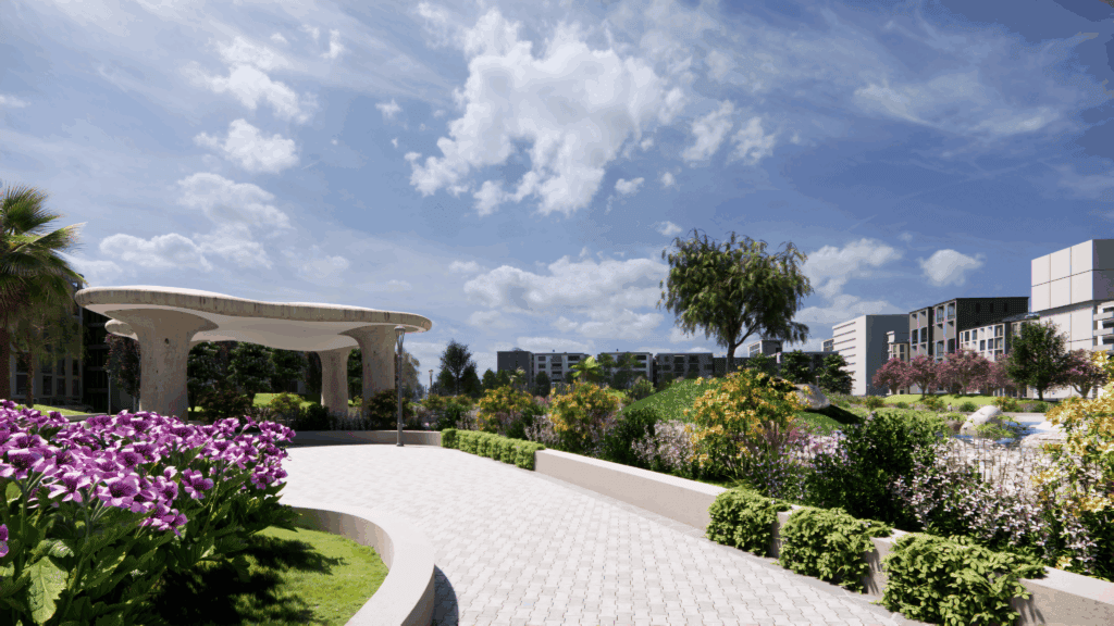
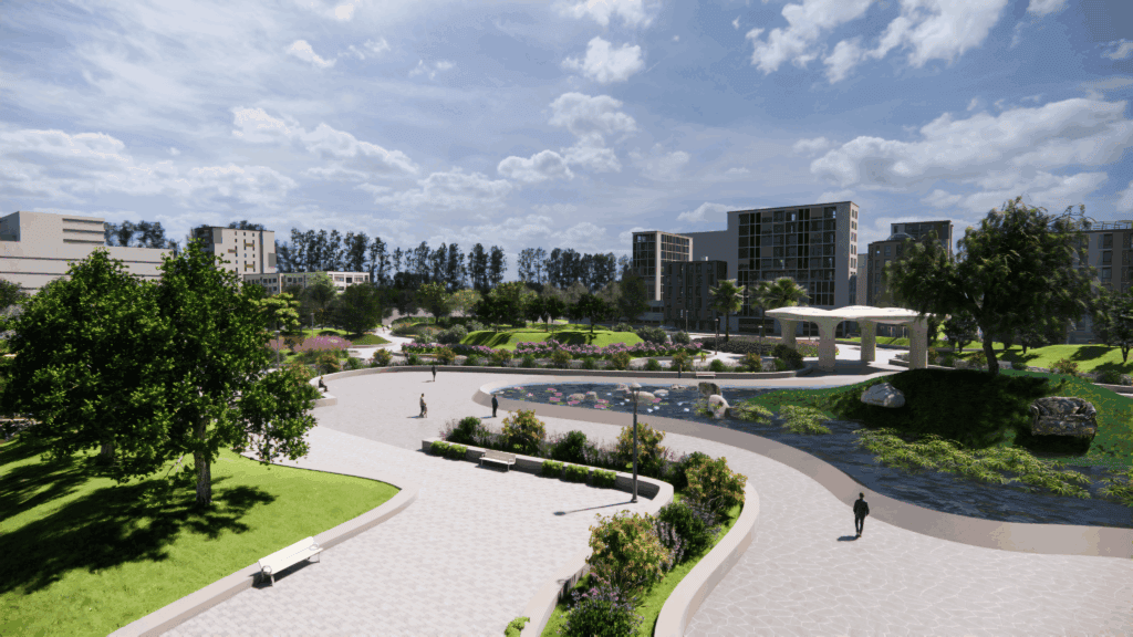
Biodiversity Park is an ambitious ecological restoration project that blends native ecology with contemporary design. What makes this project stand out is its complete design and modeling workflow using RhinoLands—a powerful 3D modeling software for landscape architects, garden designers, and urban planners.
From conceptual sketches to real-time ecological simulations, RhinoLands enabled the team to plan every element with precision. Whether it was water flow, plant combination, or microclimate effects, RhinoLands’ modeling tools ensured the vision was as functional as it was beautiful.
Key Features
- Native Plant Zones
- Using RhinoLands’ plant database and climate modeling, zones were designed to mimic local ecosystems.
- Dynamic Topography Modeling
- Terrain tools modeled slope, water retention, and runoff behavior.
- Ecological Layering
- The software enabled vertical design: from tree canopy to undergrowth to soil organisms.
- Stakeholder Collaboration
- Designers, ecologists, and planners collaborated in real-time using RhinoLands’ 3D model, its BIM integration, and CAD software compatibility.
Strategies for Designing Biodiverse Landscapes
1. Naturalistic Gardens
The Biodiversity Park follows naturalistic garden principles—favoring native and regionally adapted plants, layered ecosystems, and minimal hard edges. Combined with permaculture design, it creates low-maintenance, high-yield landscapes.
2. Leveraging 3D Modeling Software
Designing biodiversity-rich spaces used to be a complex guessing game. But with tools like RhinoLands, landscape architects can now model biodiversity outcomes before planting begins.
Key Digital Features:
- Real-time shading and sun exposure
- Rainfall simulation and drainage mapping available using Grasshopper
- Wildlife habitat zone overlays (GIS files can be opened in RhinoLands)
- Visualization of bloom cycles and foliage changes
These allow for more informed decisions and optimized land use—critical for large-scale parks and urban green spaces.
Read more about Green living spaces: a guide to sustainable landscape
3. Integrating Biodiversity Into Urban Design
Urban design and urban planification are shifting toward green infrastructure. Biodiversity Park sits at the edge of urban development and functions as a green lung—thanks to its smart integration of biodiversity into an urban planning context.
With RhinoLands, the design team created biodiversity corridors, natural noise buffers, and pollinator gardens that blend seamlessly with nearby built environments.
How RhinoLands Helps Promote Biodiversity Through Technology
From Design Concept to Living System
RhinoLands allows landscape and architecture teams to move beyond static blueprints. Its interactive design tools translate ecology into design logic:
- Select species based on pollinator value and soil type
- Predict biodiversity indices with each layout change, through connecting to Rhino Ecology
- Visualize species combination over 10+ years
CAD and BIM Integration
RhinoLands syncs with CAD programs and BIM workflows, making it perfect for multi-disciplinary projects where ecology, infrastructure, and landscape architecture intersect.
Designers can also export to other 3D model programs or bring in GIS files and satellite imagery to overlay existing conditions, which is ideal for sensitive sites like wetlands or degraded urban edges.
Community and Stakeholder Engagement
This project highlights a lesser-known advantage of RhinoLands: the ability to generate immersive 3D walkthroughs, renderings, and animated flythroughs. These visuals help non-technical stakeholders grasp the design’s ecological benefits and are pivotal for securing community and municipal buy-in. An animation produced in RhinoLands—shared as a short video or looping GIF—keeps everyone engaged and aligned around the design outcome.
Conclusion
As the design and landscape professions shift toward climate resilience, biodiversity is becoming a design imperative—not just a bonus. With a powerful modeling tool, landscape architects and planners will have the power to create ecologically rich environments that are data-informed, visually compelling, and functionally regenerative.
The Biodiversity Park stands as a testament to what’s possible when cutting-edge technology meets ecological wisdom. It’s not just a park—it’s a model for the future of landscape design from concept to visualization.